Summary
As a way of exploring my relationship to physical places, digital simulations, and imaginary worlds in media and video games, I used existing open-source projects to download, modify, print, and arrange 3D models of the focal points of my daily life in Worcester, Massachusetts. The resulting diorama is experiment in mapping and physicalizing my own internal map of where I live.
At the American Association of Geographers 2025 conference, I presented this work as part of the Outer Cartographies session. The following is adapted from a paper write-up of that work.
Publications
Conference Presentation
- Godwin, D. (2024, March). A Homunculus of Place: Tactile Cartographies of Internal Worlds. AAG Annual Meeting 2025, Detroit, MI, USA.
A Homunculus of Place: Tactile Cartographies of Internal Worlds
Abstract
Internal visuospatial imaginations are influenced by dominant cartographic conventions, but the maps that shape peoples’ view of the world are, in this process of internalization, warped, distorted by axes of access and identity, and shaped by built environments. This paper explores the confluence of multiple cartographic imaginaries in forming internal maps of place. It then outlines a practice of physicalizing the impossible dreamscapes that arise from the interaction of the physical world with myriad simulated and imaginary geographies, from pop culture, to Google Earth, to video game environments. The practice of physicalizing internal maps of place involves ripping 3D model assets from Google Earth, processing them in open software to deform spatial relationships exploratively and intuitively, and 3D printing the resulting forms. Borrowing from art therapy techniques, these forms are then arranged in space according to how they relate to the practitioner, making tactile and playful the bundling of spatial material into a sense of place. The resultant “homunculus of place” is not only visual but manipulable and changeable, inviting the practitioner to reflect on their idiosyncratic cartographies and how they may change over time and in relation to different axes of identity. This practice emphasizes that ubiquitous and uniform online maps and simulated earths affect internal cartographies but are not themselves immune to idiosyncratic warpings. This paper advocates for the playful reappropriation of geospatial technological assets as an act of opening a creative space for reflection and growth.
Introduction
In a time of exploding geographic information, readily accessible and integrated into daily life, cartographic technology shapes how we imagine place. These technologies are created with ease-of-use in mind for end users, supporting the bottom line of the companies who research, develop, and produce them. This cartography-as-a-service organizes spatial data with the promise of utility and accuracy to the physical world, allowing digital cartography to permeate daily life, guiding decisions on where to eat, sleep, travel, shop, and live.
Dominant cartographic conventions derive from the utilitarian view of maps as an accurate and unbiased reflection of reality. Critical cartographers argue that maps should be read as representations of “the culture that produces them as much as they area representation of a section of the earth or activities upon it” (MacEachren 1995, 10). In this view, the historical aim of cartography has been to create authoritative maps which are used as tools in the navigation of space for the purposes of those with power.
Modern conventions of digital cartography can therefore be seen as ways to commodify spatial data by making them readable and usable to end users with buying power. Symbols of place on the map – place markers, roads, restaurant review metadata, and more – are geared towards a public that values the places which are marked, which travels by road, and which has the money to go to restaurants and other commercial points of interest. A major addition of Google’s digital cartography-as-a-service to this dynamic is how adaptive and iterative it is – data from users is incorporated into the map, setting up a self-reinforcing feedback loop which guides users towards the same places that many others have already reviewed favourably.
This algorithmic guidance shapes the reality that such digital cartography projects aim to faithfully reproduce. This affects the individual experience of place in two ways: first, people are given an authoritative visual language for imagining where they are in reference to the all-representational digital map, including high-resolution satellite and aerial imagery not publicly available before 2005. Second, people are algorithmically guided towards focal points which have the broadest appeal, homogenizing the experience of place.
The ubiquity of smartphone access to cartographic representations of Earth has also been shown to reduce environmental knowledge and a sense of direction, as an algorithm handles the complicated task of calculating optimal routes through a place (Miola et al. 2024). This optimization of navigation reflects a value for destination over journey, goals over process, a disinterest in exploration, and a disengagement from intermediary places which are unmarked and unremarkable.
Everyday engagement with unremarkable places is a key component of how individuals build a personal relationship with place, in which a place becomes not just a backdrop but a supporting player. Yi-Fu Tuan distinguishes these types of places as constituting a “field of care”: “The feel of the pavement, the smell of the evening air, and the colour of autumn foliage become, through long acquaintance, extensions of ourselves — not just a stage but supporting actors in the human drama” (Tuan 1979, 452).
Place becomes a part of people through repeated exposure, and in this process unremarkable things become part of the internal and personal world. Disengagement from the unremarkable and everyday experience of a place curtails the formation of these “fields of care”.
However, the physical world is not the only space individuals navigate. Interactive fictional worlds engage the same regions of the brain that are used for spatial navigation in the physical world, and in their own way also become part of an internal sense of place. The practice of imagining other worlds affects the way that we think about the world we inhabit physically, as well. When we engage with and play within imaginary worlds, these influence our sense of real-life places.
While cartographic conventions affect our sense of place, the worlds we imagine and participate in, in their turn, warp and distort how we imagine dominant cartographies. There is a realm of possibility for how an individual incorporates imaginaries, cartographies, and realities into an idiosyncratic sense of place. Our physical contexts and internal worlds change how we internalize dominant cartographic depictions.
In this paper, I present a creative mapping project I completed as a case study in how breaking the cartographic rules can be used to reflect on and embrace the disobedience of internal maps of place. The purpose of this project was to make the connections between the physical, digital, and imaginary tactile through play with digital and physical form. In doing so, I explored my own sense of place at a specific point in time and how it was influenced by these connecting factors. As a product of this exploration, I created a ‘Homunculus of Place’, a distorted physical representation of my relationship to place.
Physical Contexts
This paper and the methods used to create the product are inspired by specific experiences of place. These experiences of place built up to a feeling of isolation and alienation from my environment, inspiring this project out of a desire to explore and repair my relationship to the place I lived.
Chicago, IL 2018-2020
The first experience of place that led to this project was living in Chicago from 2018 to 2020, at the end of which I was just beginning to feel a sense of affection and familiarity with the place I lived. The unremarkable features of my everyday journeys around the city started to join my internal world, shaping my narrative of where I was and why. The streets I took to and from work, friends’ apartments, and the lake became part of my field of care in Chicago, and my narrative of place was integrated into my story of self.
I also encountered 3D printed maps of Chicago at an art fair, created by J.D. Dennison (Dennison, 2025). I was fascinated by how tactile the models were, and they were an early inspiration for the form and medium of the product of this project.
Chicago, IL 2020-2022
In January 2020, the first case of COVID presented in Chicago. By mid-March, a disaster proclamation went out, leading to the closure of the kind of “third places” that act as spaces for spontaneous and playful connection. The sense of connection to place I had felt gave way to a feeling of isolation and alienation. My field of care lost coherence and with it, I felt a fragmentation of my identity. I spent my time shuttling between two places: behind a mask at a restaurant job during lockdown and at home in my apartment. The places that had been part of my field of care lost their glow and meaning, reflecting a process Yi-Fu Tuan writes about in relation to fields of care:
“The emotion felt among human beings finds expression and anchorage in things and
places. It can be said to create things and places to the extent that, in its glow, they
acquire extra meaning. The dissolution of the human bond can cause the loss of
meaning in the material environment.” (Tuan 1979, 453)
The dissolution of the human bonds that anchored my experience of place led to a loss of that meaning my everyday places had gained.
Worcester, MA 2020-2022
After moving to Worcester for a graduate program at Clark University, I reacted against my feelings of alienation in Chicago by involving myself in as many third places as my day would allow. However, I didn’t allow myself affection towards the unremarkable space between these places, since the difference in geography and built environment between Chicago and Worcester shaped how I related to the cities in ways I didn’t expect. The distance between places in Worcester, with its car-oriented streets, low density, and steep hills, amplified the feelings of alienation I had begun to feel in Chicago. I began to imagine the key places in my life as islands floating in a hostile, hard-to-traverse medium.
Imaginary Worlds
During the COVID lockdown in Chicago, I substituted a lost sense of connection to place with more time spent in fiction. These fictional worlds converged with my fragmented sense of who and where I was during this time and remain strong influences in how I imagine the world around me. Two specific pieces of media were most influential in the methods and form I chose for this project.
Dark Souls III
In this game, the world is tired and coming apart. Space and time become confused and incoherent. Places that are familiar to the player are revisited in ways that do not make narrative sense and show up interconnected in unexpected and physically impossible ways. The gameplay is designed to be punishing to mistakes. Between brief oases of safety, the player traverses hostile gauntlets, expecting to die repeatedly and to lose scarce resources each time. The story of the game is opaque and oblique, and without prior knowledge the player will know almost nothing about who they are, how the world came to be the way it is, where to go, or why they are doing anything at all. The game uses its cartography and level design to communicate its vision of a world which is losing meaning and purpose. The last area of the game, the Dreg Heap, is a striking visual metaphor for a collapsing narrative of place – every previous location is piled into a physically impossible and meaningless amalgam.
![]() The Dreg Heap in Dark Souls III
The Dreg Heap in Dark Souls III
In playing this game during the 2020 lockdown, I started to associate my own world with the world of the game. The places that had held a certain meaning before now felt alien, and the space separating them had become hostile. Existing relationships to and between places had changed in ways that were not yet clear. The experience of navigating Chicago felt analogous to traversing hostile gauntlets between pockets of safety with no clear idea of why.
Studio Ghibli
Many films from animation company Studio Ghibli take place in a previously recognizable world that is made otherworldly through the course of the film. Spirited Away sees its protagonist from modern Japan transported to a realm of spirits (Miyazaki 2001). The protagonists of Castle in the Sky flee an oppressive industrial regime to a floating island city built around a massive tree (Miyazaki 1986). The last act of Ponyo shows the seaside town of the film’s setting flooded and transformed into a chain of islands (Miyazaki 2008).
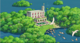

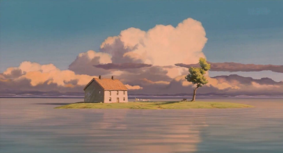 Clockwise from top left: stills of Ponyo, Castle in the Sky, and Spirited Away.
I watched these films as a form of escape with my roommates, but the imagery of floating islands, dreamlike waterscapes, and transformation of a setting into something unrecognizable but familiar stuck with me and related, in my mind, to the fragmentation of my previously familiar world into islands separated by negative space.
Dominant Cartographies
This broken relationship with place was a strong influence in my choice to go back to school and move away from Chicago. In anticipation of my move, I spent hours poring over and idealizing the Google Earth representation of Worcester, planning the ways in which my life would improve once I got there. I imagined the new routes I would take and the places, represented in polygons on a screen, that would become my life.
Google Earth’s mission to create a digital twin of Earth relies on satellite imagery, airborne topography scans, and sophisticated algorithms to bring the data together into a coherent simulation. Originally specialized software developed by Keyhole Inc. as part of its Earth Viewer program, it was acquired by Google in 2005 and retooled for non-expert use. It lowers the barrier to entry and recontextualizes technology originally funded and developed as tools for military intelligence and scientific inquiry as tools for everyday users to navigate and expand their horizons.
The collaborative mapping aspect of the platform serves to destabilize the concept of this map as an authoritative cartographic representation, as Farman argues: “user-generated content disseminated in Google Earth by the social network is a tool that ultimately reimagines the status of the map presented by Google and the viewer’s relationship to that map” (Farman 2010, 29). The author likens the process and products of user engagement in the platform to bricolage, in which users navigate the “psychogeography” of Google Earth and reconfigure the sign systems, subverting the power dynamic presented by dominant cartographic conventions.
The Sensory Homonculus
The sensory homunculus is a long-standing experiment in neurological cartography. Based on work by Penfield and Boldrey, the homunculus is a physical representation of the body according to the cortical surface area associated with each body part (Penfield and Boldrey 1937). It is an attempt to visualize the relationship between the body and the brain, in which some body parts, especially the hands, lips, and face, have greater and broader neural connectivity and thus a larger ‘place’ in the brain than others, such as the limbs and torso. The result is a warped humanoid figure portraying the way the brain perceives the body in terms of nerve density. A physical representation of this is created by artist Sharon Price-James, an image of which is shown below (Price James 2025).
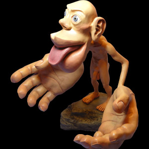
In thinking about my relationship to Worcester and Chicago, I saw an analogue for my sense of place in the sensory homunculus. The focal nodes of each place were larger, more detailed, and more focused in my mental map of the external world than the areas connecting them. Space was thin and undifferentiated between the areas I gave attention and care to, in a similar way to how the limbs of the sensory homunculus are thin and spindly between the areas which receive the most neural attention.
Methods
Digital Manipulation
The first step of this project was to rip 3D models directly from Google Maps and experiment extensively with them in Blender, an open-source modelling software To obtain the 3D models, I used an open-source package named MapsModelImporter (Michel 2024) along with another named RenderDoc (Karlsson 2024). This is possible because Google Maps renders imagery on the hardware of the machine accessing it, meaning that by injecting additional code into this process, the data from Google Maps can be intercepted and saved to the user’s machine.
Once I had the data in blender, I found it was not inherently 3D printable. A 3D print requires that a mesh be “manifold”, meaning that there are no holes and every edge, face, and point is connected to an edge. This can be thought of as a “watertight” model. Since the Google Maps data is only intended for visual rendering, with an emphasis on speed of processing, the models do not conform to this requirement. The models from Google Maps can be thought of more like papier mâché than a cohesive sculpture. There are many overlapping and intersecting edges and holes in the mesh surface that it is not possible to fix. My method was to use the data from Google Maps as a frame on which to construct a new manifold mesh.
This method digitally mimics the process of taking that rough, paper-mâché-like original Google Maps data and vacuum-forming a sheet of rubber to it. There are imperfections and some loss of detail, but for small-scale prints, this is an effective hack to make Google Maps 3-D printable.
The topographic map was created using Light Detection and Ranging (LiDAR) derived Digital Elevation Map (DEM) data from the United States Geological Survey (USGS), accessed through OpenTopography (OpenTopography 2021). I downloaded the data from my region of interest, in this case the Main South area of Worcester MA, and imported it into Blender with no further modifications.
3D Printing
After creating these printable files, I used the free 3D printing service at the Worcester Public Library as well as an online service called CraftCould. I used Cura to format the files. While the Worcester Public Library did print an example, their policy about prints being a certain maximum size and only having one print in the queue at once meant that there was not enough time available to print the materials at the library. All the prints for the final product were made through CraftCloud. Total cost for this project was 18 on combined shipping and handling for all prints.
Physical Assembly
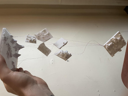
I used a pourable epoxy resin kit to simulate water on the topographic map. I created a border using masking tape and used books to hold up the sides of the resin while it cured. I created holes in the 3D prints using a sewing awl heated with a butane torch. The hot awl melts the plastic of the print. For each city block, I created one hole in the physical location I go to within it and one hole at the corner for suspension from the topography map.
I then used the same technique of heating an awl to create holes in the geographic locations corresponding to each city block in the topographic map. I used fishing wire to suspend each print. While assembling, I realized that the easiest way to suspend the city blocks was also the most thematically resonant - each print is hung on the same piece of fishing line as one other that occupies a similar spot in my life, such that the length of the suspension of one depends on the other. For example, Clark University (a large heavy print, symbolizing its centrality to my purpose in Worcester) is tied to a line which threads up through its location, over the top of the topographic print, and back down to Wooden Bar, where I work a part-time job. When Clark pulls itself down with its gravity, Wooden Bar (which is a smaller print, showing how it can become peripheral to my life) is pulled up and more out of sight. They are in tension with each other. The map is manipulable by its viewer - pulling Wooden Bar down, separating it out from the other places and into sight, necessarily pulls Clark up and out of sight. This reflects the tension between places in my mind that often pull on each other for attention.
I then threaded a red piece of string through the holes in each place, connecting them together in a typical journey between them. The distance of this journey in the map representation depends on the position of the places relative to each other, and the position of each is bounded to the position to its complement. This results in a map which reflects the tension between different places in my life, the values they represent, and the fluctuating conceptual distance between them.
The process of 3D data extraction, manipulation, printing, and assembling is an extension of Farman’s ideas of user engagement with Google Earth as a form of bricolage (Farman 2010, 27). In the case of this project, I take the process outside the confines of the Google Maps platform, repurposing the elements of that cartography to explore the disparate ideas, imagery, and experiences I assemble psychologically into a narrative of place.
Results
In taking inspiration from JD Dennison’s printed maps of Chicago, I chose 3D printed white PLA for the medium. This raw, undyed material helps the colors representing travels in physical and internal space pop out from their context. The minimal aesthetic of the pieces also shows them to be a blank canvas on which internal associations and connections are projected.
This relates to the cartographic design principle of establishing a figure-ground relationship and a visual hierarchy. The 3D printed city blocks and elevation map of Main South constitute the ground of the map. Given that they are 3 dimensional, unpainted, and undyed, the map relies on shadow and light to show the form of the areas. This gives them a dreamlike quality and allows them to be observed from multiple angles and in multiple lighting conditions. Unlike a printed map, there is no “ideal” lighting condition for color fidelity or readability. The piece, if observed in the absence of light, could even be experienced as tactile, through touching the pieces and tracing the lines between them, undifferentiated by color.
The design also establishes another form of ground, that of negative space. Negative space between the prints allows them to be arranged in relationship to each other. The space between each of the elements is bridged by the brightly colored thread, forming a visual hierarchy where the eye is drawn most strongly to the threads representing travel between different geographic and mental spaces, emphasizing the tension between the simultaneous connection and distance of places on this map.
Hierarchy is also explored in the use of height, distance, and gravity. The geographic basis which informs the relationship of the city blocks in physical space is the topography map. The topography map forms something like the base of a mobile or the mounting point for windchimes - it is at the top, unifying the place elements, yet is not one of them. It is the setting for the elements of the map.
The city blocks are arranged semi-instinctually along the z-axis of suspension. I was inspired by an experience that my best friend related to me about their time in a psychology ward for rehabilitation. An art therapist asked patients to select animal figurines from a collection to represent people and relationships. For example, a shark could represent a patient, a giraffe could represent their partner, a tiger could represent their romantic relationship, etc. Then, the therapist asked patients to arrange these figures in relation to each other in something like a tableau or creche. For example, the shark could be close to and facing the tiger, the giraffe could be facing away, and the tiger could be on its back, according to what felt right or true to the patient.
My arrangement of the places that constitute the bulk of my internal map of Worcester follows a similar practice - unlike a traditional map, there is no definite unit to the z-axis. What it represents is the places’ relations to each other. Distant places, even though they may be close geographically, are distant conceptually, emotionally, internally. The places that I chose to physically represent in relation to each other are those which have the greatest weight of attention and emotional connection in my life. While they are not instantly recognizable to an outsider, I can immediately tell which is which. The fact that the places are not fixed, and move dynamically around each other, shows that my conceptualization of place is subject to continuous change and reformations. In Dark Souls III, environments are the product of shifting realities. In Castle in the Sky, the titular castle moves secretly through the clouds. My internal representation of my environment shifts according to my thoughts, emotions, and experiences.
The process of arranging and connecting the focal points of this map are a physical representation of the process of place-bundling: “Individuals bundle – that is, make places – by referencing and (re)configuring the many simultaneous places that they participate in; these placebundles are socially negotiated, constantly changing and contingent” (Pierce et al. 2011, 58). The map is a physical bundle of places I participate in, showing that this configuration of places is always changing, floating in space, with each element bound up and in and contingent to the others.
Conclusion
This paper documents an experimental method of exploring a personal relationship to place through the playful appropriation of the same digital assets that constitute an authoritative cartography. While the methods here are specific to an individual experience of place, they highlight the potential of making the imaginary physical, expanding what constitutes an appropriate subject of mapping, and using digital cartography as a process of exploration rather than a means to meet a specific need with a specific map as a product. Digital cartography can be a medium of play, exploration, and reconfiguration.
References
- Blender Foundation. 2024. Blender. V. 4.1. Released March 26
- Farman, Jason. 2010. “Mapping the Digital Empire: Google Earth and the Process of Postmodern Cartography.” New Media & Society 12 (6): 869–88. https://doi.org/10.1177/1461444809350900.
- FromSoftware. 2016. Dark Souls III.
- JD Dennison. 2025. “Fine Art 3d Printed Wall Sculptures | Architectural Wall Art |3d Print Map|.” https://jddennison.com/.
- Karlsson, Baldur. 2024. RenderDoc. Released April 5.
- MacEachren, Alan M. 1995. How Maps Work: Representation, Visualization, and Design. Guilford Press.
- Michel, Elie. 2024. MapsModelImporter. V. 0.7.0. Released April 4.
- Miola, Laura, Veronica Muffato, Enrico Sella, Chiara Meneghetti, and Francesca Pazzaglia. 2024. “GPS Use and Navigation Ability: A Systematic Review and Meta-Analysis.” Journal of Environmental Psychology 99 (November): 102417. https://doi.org/10.1016/j.jenvp.2024.102417.
- Miyazaki, Hayao, dir. 1986. Castle in the Sky. Toei.
- Miyazaki, Hayao, dir. 2001. Spirited Away. Toho.
- Miyazaki, Hayao, dir. 2008. Ponyo. Toho.
- OpenTopography. 2021. “USGS 1 Meter Digital Elevation Model.” Preprint, OpenTopography. https://doi.org/10.5069/G9NP22NT.
- Penfield, Wilder, and Edwin Boldrey. 1937. “SOMATIC MOTOR AND SENSORY REPRESENTATION IN THE CEREBRAL CORTEX OF MAN AS STUDIED BY ELECTRICAL STIMULATION.” Brain 60 (4): 389–443. https://doi.org/10.1093/brain/60.4.389.
- Pierce, Joseph, Deborah G Martin, and James T Murphy. 2011. “Relational Place‐ making: The Networked Politics of Place.” Transactions of the Institute of British Geographers 36 (1): 54–70. https://doi.org/10.1111/j.1475- 5661.2010.00411.x.
- Price-James, Sharon. 2025. “Introduction to Sensory Homunculus.” Business Site. https://www.sharonpricejames.com/.
- Tuan, Yi-Fu. 1979. “Space and Place: Humanistic Perspective.” In Philosophy in Geography, edited by Stephen Gale and Gunnar Olsson. Springer Netherlands. https://doi.org/10.1007/978-94-009-9394-5_19.
- U. S. Geological Survey. 2021. “3D Elevation Program 1-Meter Resolution Digital Elevation Model.”